inkscape
 tech.michaelaltfield.net
# Make Vector Topographic Maps (Open Street Map, Maperitive, and Inkscape) #### by Michael Altfield This guide will show you how to [generate vector-based **topopgraphic maps**](https://tech.michaelaltfield.net/2024/10/01/osm-contours-svg-maperitive/), for printing very large & **high-quality paper wall maps using inkscape**. All of the tools used in this guide are free (as in beer). | [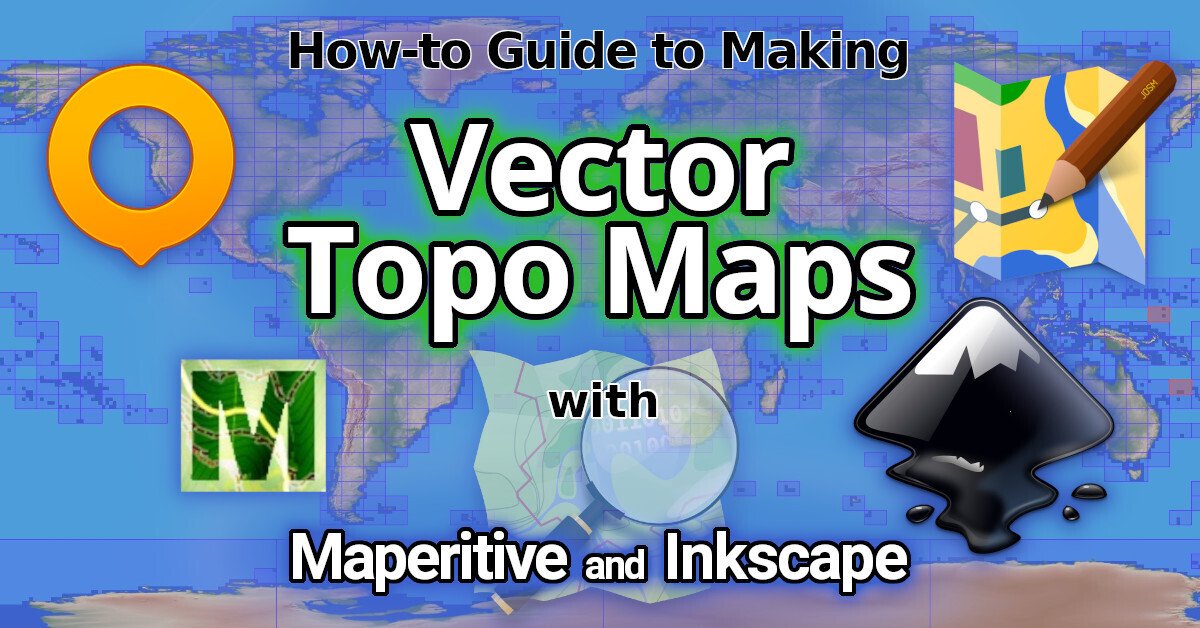](https://tech.michaelaltfield.net/2024/10/01/osm-contours-svg-maperitive/) | |:--:| | How-to [Guide to Making Vector Topo Maps](https://tech.michaelaltfield.net/2024/10/01/osm-contours-svg-maperitive/) with Maperitive and Inkscape | # Intro I recently volunteered at a Biological Research Station located on the eastern slopes of the Andes mountains. If the skies were clear (which is almost never, as it\'s a cloud forest), you would have a great view overlooking the Amazon Rainforest below. | [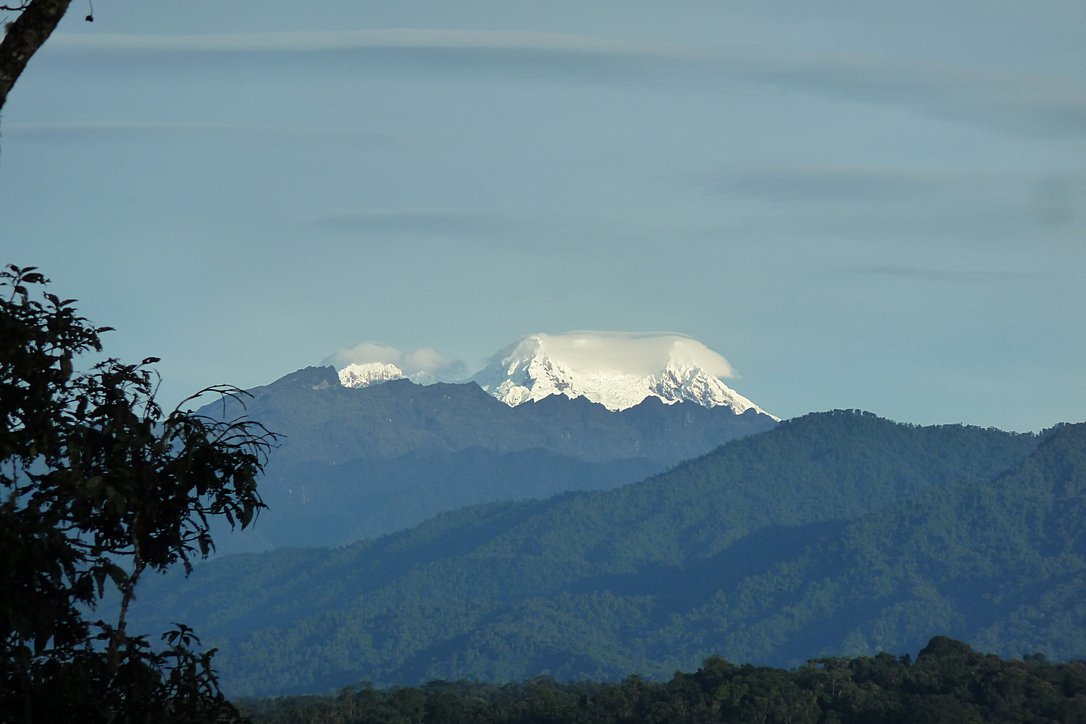](https://tech.michaelaltfield.net/2024/10/01/osm-contours-svg-maperitive/) | |:--:| | Yanayacu is in a cloud forest on the east slopes of the Andes mountains, just 30 km from the summit of the glacial-capped [Antisana](https://en.wikipedia.org/wiki/Antisana) volcano ([source](https://commons.wikimedia.org/wiki/File:Volc%C3%A1n_Antisana_2015-06-14_(9)_(39680659444).jpg)) | The field station was many years old with some permanent structures and a network of established trails that meandered towards the border of Antisana National Park -- a protected area rich with biodiversity that attracts biologists from around the world. At the top of the park is a glacial-capped volcano with a summit at 5,753 meters. Surprisingly, though Estacion Biologicia Yanayacu was over 30 years old, nobody ever prepared a proper map of their trails. And certainly there was no high-resolution topographical map of the area to be found at the Station. That was my task: to **generate maps that we could bring to a local print shop to print-out huge 1-3 meter topographical maps**. And if you want to print massive posters that don\'t look terrible, you\'re going to be working with **vector graphics**. However, most of the tools that I found for browsing Open Street Map data that included contour lines couldn\'t export an SVG. And the tools I found that *could* export an SVG, couldn\'t export contour lines. It took me several days to figure out how to render a topographical map and **export it as an SVG**. This article will explain how, so **you can produce a vector-based topographical map in about half a day** of work. ## Assumptions This guide was written in 2024, and it uses the following software and versions: 1. Debian 12 (bookworm) 2. OsmAnd\~ v4.7.10 3. JOSM v18646 4. Maperitive v2.4.3 5. Inkscape v1.2.2 ## The Tools Unfortunately, there\'s no all-in-one app that will let you just load a slippy map, zoom-in, draw a box, and hit \"export as SVG\". We\'ll be using a few different tools to meet our needs. | [](https://tech.michaelaltfield.net/2024/10/01/osm-contours-svg-maperitive/) | |:--:| | [OsmAnd](https://osmand.net/) | ### OsmAnd [OsmAnd](https://osmand.net/) is a mobile app. We\'ll be using OsmAnd to walk around on the trails and generate GPX files (which contain a set of GPS coordinates and some metadata). We\'ll use these coordinates to generate vector lines of a trail overlaying the topographic map. If you just want a topographic map without trails (or your trails are already marked on OSM data), then you won\'t need this tool. In this guide we\'ll be using OsmAnd, but you an also use other apps \-- such as [Organic Maps](https://organicmaps.app/), [Maps.me](https://maps.me/), or [Gaia](https://www.gaiagps.com/). | [](https://tech.michaelaltfield.net/2024/10/01/osm-contours-svg-maperitive/) | |:--:| | [JOSM](https://josm.openstreetmap.de/) | ### JOSM [JOSM](https://josm.openstreetmap.de/) is a java-based tool for editing Open Street Map data. We\'ll be using JOSM to upload the paths of our trails (recorded GPX files from OsmAnd) and also to download additional data (rivers, national park boundary line, road to the trailhead, etc). We\'ll then be able to combine all of this data into a larger GPX file, which will eventually become vector lines overlaying the topographic map. You can skip this if you just want contour lines without things like rivers, roads, trails, buildings, and park borders. ### View Finder Panoramas Have you ever wondered how you can zoom-in almost anywhere in the world and see contour lines? I always thought that this was the result of some herculean effort of surveyors scaling mountains and descending canyons the world-over. But, no \-- it\'s a product of the US Space Shuttle program. In the year 2000, an international program called [SRTM (Shuttle Radar Topography Mission)](https://en.wikipedia.org/wiki/Shuttle_Radar_Topography_Mission) was launched into space with the Endaevor Space Shuttle. It consisted of a special radar system tethered to the shuttle with a 60 meter mast as it orbited the earth. | [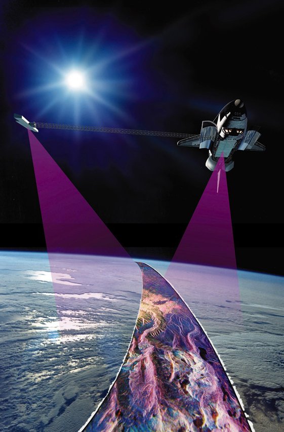](https://tech.michaelaltfield.net/2024/10/01/osm-contours-svg-maperitive/) | |:--:| | This illustration shows the Space Shuttle Endeavour orbiting \~233 kilometers above Earth. The two anternae, one located in the Shuttle bay and the other located on a 60-meter mast, were able to penetrate clouds, obtaining 3-dimentional topographic images of the world\'s surface (source: [NASA](https://commons.wikimedia.org/wiki/File:Shuttle_Radar_Topographic_Mission_(SRTM)_Illustration.jpg)) | When the shuttle returned to earth, the majority of our planet\'s contours were mapped. This data was placed on the public domain. Today, it is the main data source for elevation data in most maps. While the data from SRTM was a huge boon to cartographers, it did have some gaps. Namely: elevation data [was missing](https://en.wikipedia.org/wiki/Shuttle_Radar_Topography_Mission#No-data_areas) in very tall mountains and very low canyons. Subsequent work was done to fill-in these gaps. One particular source that ingested the SRTM data, completed its gaps, and made the results public is Jonathan de Ferranti\'s [viewfinderpanoramas.org](https://viewfinderpanoramas.org/Coverage%20map%20viewfinderpanoramas_org3.htm). We will be downloading [`.hgt`](https://stackoverflow.com/questions/357415/how-to-read-nasa-hgt-binary-files) files from View Finder Panoramas in order to generate vector contour lines for our topographical map. | [](https://tech.michaelaltfield.net/2024/10/01/osm-contours-svg-maperitive/) | |:--:| | [Maperitive](http://maperitive.net/) | ### Maperitive [Maperitive](http://maperitive.net) is a [closed-source](http://maperitive.net/docs/FAQ.html#Where%20is%20the%20source%20code?) .NET-based mapping software (which runs fine in Linux with [mono](https://www.mono-project.com/)). We\'ll be using Maperitive to tie together our GPX tracks, generate contour lines, generate hillshades, and export it all as a SVG. | [](https://tech.michaelaltfield.net/2024/10/01/osm-contours-svg-maperitive/) | |:--:| | [Inkscape](https://inkscape.org/) | ### Inkscape [Inkscape](https://inkscape.org/) is a cross-platform app for artists working with vector graphics. We\'ll be using inkscape to make some final touches to our vector image, such as hiding some paths, changing their stroke color/shape/thickness, and adding/moving text labels. Finally, we\'ll use inkscape to export a gigantic, high-definition `.png` raster image (to send to the print shop). # Guide To read the full guide on how to create vector-based maps, [click here](https://tech.michaelaltfield.net/2024/10/01/osm-contours-svg-maperitive/): * [tech.michaelaltfield.net/2024/10/01/osm-contours-svg-maperitive](https://tech.michaelaltfield.net/2024/10/01/osm-contours-svg-maperitive/) # Example Maps For example, here\'s the (A4-sized) topo map that I built for Yanayacu. | [](https://tech.michaelaltfield.net/2024/10/01/osm-contours-svg-maperitive/) | |:--:| | Final (raster) export, ready for sending to the print shop ([source svg](https://github.com/maltfield/yanayacu/blob/main/maps/yanayacu_topo/yanayacu_topo.svg)) | Note that I changed the stroke and thickness of the National Park boundary to be large and green, I changed the path of the road (downloaded from OSM data in JOSM) to be thick and black, and I changed my GPX tracks (recorded in OsmAnd and merged with the OSM data in JOSM) to be thin, dashed, and red. The source `.svg` file for the above image can be found [here](https://github.com/maltfield/yanayacu/tree/main/maps/yanayacu_topo) - [github.com/maltfield/yanayacu/tree/main/maps/yanayacu_topo](https://github.com/maltfield/yanayacu/tree/main/maps/yanayacu_topo) I also used this method to generate a simplified \"trail map\" of Yanayacu (without contour lines). The workflow was similar, except I didn\'t generate contour nor hillshades layers in Maperitive before exporting as a `.svg` | [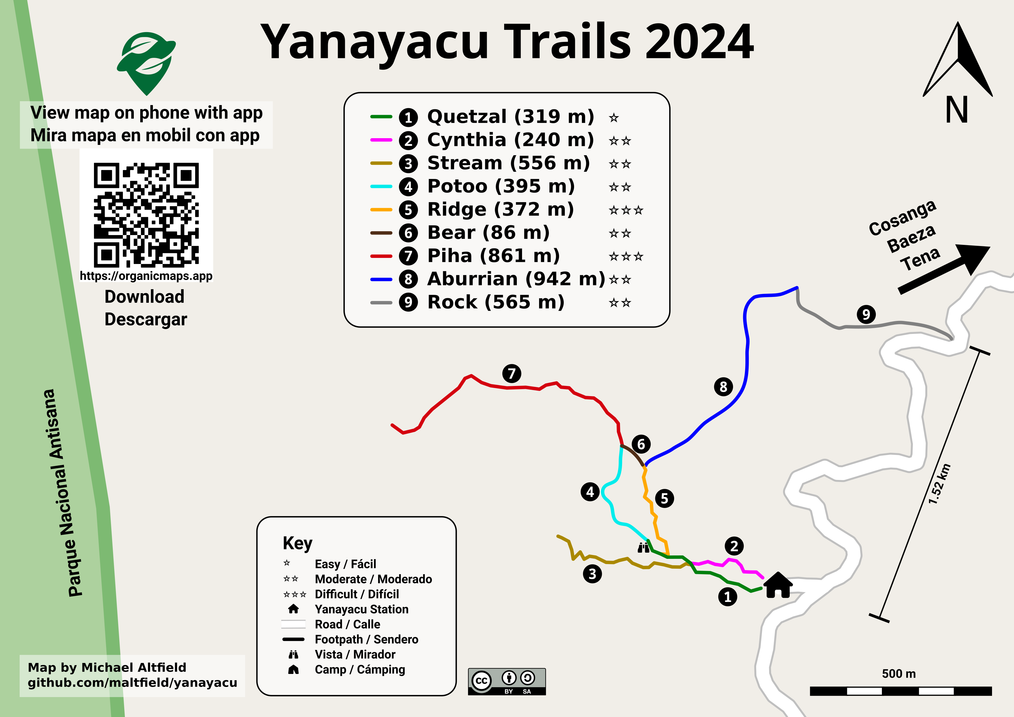)](https://tech.michaelaltfield.net/2024/10/01/osm-contours-svg-maperitive/) | |:--:| | Yanayacu Trail Guide ([source svg](https://github.com/maltfield/yanayacu/blob/main/maps/yanayacu_trail_guide/yanayacu_trail_guide.svg)) | The source `.svg` file for the above image can be found [here](https://github.com/maltfield/yanayacu/tree/main/maps/yanayacu_trail_guide) - [github.com/maltfield/yanayacu/tree/main/maps/yanayacu_trail_guide](https://github.com/maltfield/yanayacu/tree/main/maps/yanayacu_trail_guide)
cross-posted from: https://programming.dev/post/18113218 > Hi, > > Is it possible with Inkscape to squeeze a shape in a mirror way (sorry I don't know how to phrase it better) \ > > Here a gif from a rasterize/pixel editor with what I'm looking for \ >  > > > ::: spoiler The same question on the official inkscape forum > 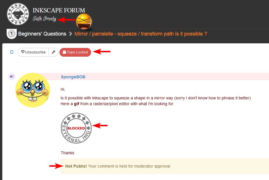 > WTF the fuck happen to peoples ? > Internet should not be a place where everyone could express, share what he want ?! > > I'm glad their is Lemmy, so quick and easy > :::

I got to make this based off of 1990s UpperDeck hockey cards. Our city Council took this photo of them in our local Jr A hockey jerseys to show support during the teams playoffs run. I used GIMP and inkscape to make this.


 www.youtube.com
Release of 1.3 incoming!

A new book about inkscape 1.3 was published by Christopher Rogers: [Design Made Easy with Inkscape: A practical guide to your journey from beginner to pro-level vector illustration](https://amzn.eu/d/dnxoiIL)
 inkscape.org
Release notes [here](https://wiki.inkscape.org/wiki/Release_notes/1.3)!

 inkscape.org
Go grab your "TESTING" copy now... https://inkscape.org/release/inkscape-1.2/?latest=1 This is for testing, bug reporting and giving user feedback!
Inkscape about screen contest really showed fine pieces of art 😍
 inkscape.org
# **Release Notes** ## **New Features** Menus We've added a link to our donation page in Help → Donate, to make it easier for users to contribute to the project financially (MR #3325) # Bug fixes ## General Thanks to the upstream fix in gtk3, pressure sensitivity works again with Windows Ink activated (Bug #1437, https://gitlab.gnome.org/GNOME/gtk/-/merge_requests/1563) Stroke to Path works on text again (Bug #2333) Undoing Stroke to Path no longer loses the object's id (Bug #2759) Undoing Object to Path for an object with a Live Path Effect is now possible without also undoing the preceding action (Bug #1504) Saving no longer leaks memory (Bug#2800) Startup times improved, 3.3 seconds to 3 seconds on one Windows machine (Commit 228b6a) Hide unnecessary warnings in terminal about optional font directories not being used (Commit 76fb99) Canvas no longer blurred when moving window from HiDPI to a regular display (Commit f7162b) Clicking selects objects again on wmii and some other window managers (Bug #2801) Caps lock no longer stops Delete, Page Down and some other shortcut keys from working on Windows (Bug #2496) ## Dialogs Clicking the resize separator will toggle visibility of docked dialog (Commit 3c8683, Bug #4676, MR #2969) Welcome dialog: Fixed a paper size typo (Bug #2570) Renamed some confusing device size names (Bug #2570) Removed an unnecessary warning when choosing the keyboard shortcuts set (Bug #2529) Transform dialog: Matrix tab no longer stubbornly insists on using display units instead of the units the user selected (Bug #2429) Text and Font dialog: Font features load in under a second, instead of minutes for fonts with lots of font features. More font feature glyphs shown too (Commit 0dacc4, MR #3449) ## Filters Fast crop: Transparency is now respected when applying the Filters → Fill and Transparency → Fast Crop filter (Bug #2419) ## Import EPS: Users that have installed Inkscape in the snap packaging format can open EPS files again (Bug #1406) ## Export Optimized SVG: Save as → Optimized SVG works again in Linux AppImage (Bug #1738) ## Markers Start / end markers: A bug was fixed where the path tip protruded over the arrow marker's end (Bug #2593). ## Menus Help menu: Now using a different set of web links to link to the documentation from the Help menu (MR #3325) ## Packaging Snap remembers user preferences even when the home directory is not available to the snap. This may occur in LDAP, SSSD, or other set ups where there is a modified nsswitch.conf and NSCD is not acting as a proxy to snaps. (MR #3474) ### Build fixes: Building Inkscape works again on systems with musl libc (MR #3410) Building Inkscape works again on NetBSD (Commit 1029bb, Commit bfb81a, Commit 160dc7, Commit e12966) Building Inkscape works again on FreeBSD (Commit 06b143) Building Inkscape works again with GCC 7 (Commit 3d8be5) ## Templates All templates generated from the 'Welcome' dialog now use a document scale of 1, making it easier to hand-edit documents created using them (Bug #2728) ## Tools Measure tool: Settings for font size and precision for the Measure tool work again (MR #3343) Position dialog moves handles to the right place again (Commit 1fcc33) Measurements no longer reset on right click or tool switch (Commit bd9349, Commit 341a0e) ## Crash fixes Fixed a crash when … … using a grid with the Document Properties dialog open on Windows. This also fixes a memory leak on other operating systems, that did not necessarily lead to a crash. (Bug #2585) … trying to copy an object without ID (Bug #2714) … stroke to path applied on paths with no area, fill, stroke, or markers (Bug #2502, Bug 2572) … entering a space character in the 'Attributes' field of the 'Clone Original' LPE settings dialog (Bug #1709) … closing a window while the filter editer dialog is floating and a filter is selected (Bug #2753) … pasting 3D boxes when the 3D box tool is active (Bug #2741) … multiple objects selected for spray tool in single path mode (#2740) … quitting in command line or when opening windows if done before window fully loads (Bug #2776, Bug #2487) … Homebrew or MacPorts used and XDG_DATA_DIRS is not defined (Commit 1a6c62) ## Extension bug fixes Fix LaTeX extension on Windows (MR #309) Add __version__ for inkex (MR #360, Bug #409)
Snapping bar only had icons , which make hard to know what does option do , this new menu solves this problem with icons along text.

 www.youtube.com
Inkscape new feature

This will be Inkscape screen for next release.
 www.youtube.com
Martin Owens one of inkscape developers give us one of his weekly reports about the the new things he worked on in inkscape
 www.youtube.com
NEW #Inkscape Podcast "Inkscope" video available. Join Inkscape's Tim Jones as he interviews the amazing artist... Sven Ebert:
inkscape
!inkscape@lemmy.ml(NON-OFFICIAL account) #OpenSource vector drawing app for Windows, MacOS & Linux. Similar to Illustrator, always free for everyone!